Information for "File:VoR paths.png"
Jump to navigation
Jump to search
View the protection log for this page.
Information from Extension:WikiSEO
Basic information
| Display title | File:VoR paths.png |
| Default sort key | VoR paths.png |
| Page length (in bytes) | 708 |
| Namespace | File |
| Page ID | 9669 |
| Page content language | en - English |
| Page content model | wikitext |
| Indexing by robots | Allowed |
| Number of redirects to this page | 0 |
| Number of subpages of this page | 0 (0 redirects; 0 non-redirects) |
| Hash value | 2973b6ccadf178fa3285e2c1d6e1eaa0381c53d2 |
| Page image |  |
Page protection
| Edit | No extra protection (infinite) |
| Move | No extra protection (infinite) |
| Upload | No extra protection (infinite) |
Edit history
| Page creator | Espyo (talk | contribs) |
| Date of page creation | 08:49, April 15, 2014 |
| Latest editor | PorpleBot (talk | contribs) |
| Date of latest edit | 02:34, April 14, 2024 |
| Total number of edits | 8 |
| Recent number of edits (within past 90 days) | 1 |
| Recent number of distinct authors | 1 |
Page properties
| Transcluded templates (4) | Templates used on this page:
|
SEO properties
Description | Content |
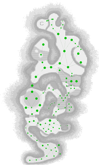
Article description: (description)This attribute controls the content of the description and og:description elements. | A graphical representation of the carrying paths in the Valley of Repose. The graph is imposed on top of the radar texture, and the paths can be found in /user/Abe/map/tutorial/route.txt, inside Pikmin 2's ISO. Note that the radar texture and the generated graph have been aligned manually, so the precision might be very slightly off. Also to note is that the radar textures don't reflect the terrain exactly, so a node that looks like it's just on top of a ledge could actually be on the floor below, for instance. |